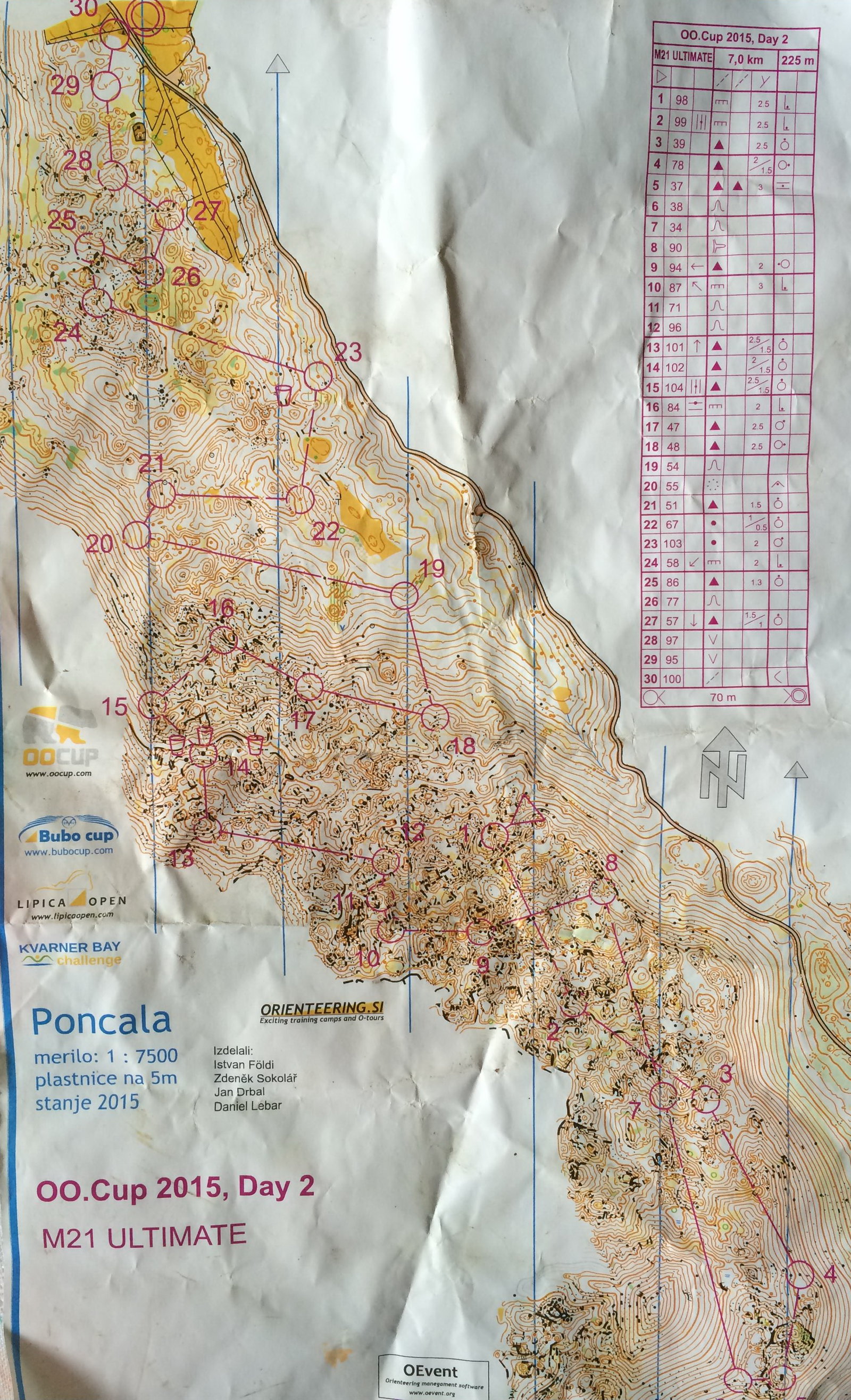
A group of friends were debating whether or not to do one of the 'Ultimate' courses at OOCup in Slovenia this year. They remove the paths from the map to make more of navigational challenge. Here's an example from a previous year.
http://news.worldofo.com/wp-content/uploads/2015/11/20.blank_s.jpg
We use filtered maps a lot in coaching sessions to target specific skills and/or make the exercise more challenging, but they're rarely used in events in this country.
In certain areas with runnable terrain, but lots of paths or walls, it would increase the challenge and breathe new life into well used maps. Perhaps also give your club's marketing team something to help sell your events!
In some areas you'd need to miss off walls, vegetation or water features as well.
Any recent or potential future examples anyone?
Ultimate Orienteering
Moderators: [nope] cartel, team nopesport
9 posts
• Page 1 of 1

Re: Ultimate Orienteering
![]() by plain lazy » Thu Jan 21, 2016 12:46 pm
by plain lazy » Thu Jan 21, 2016 12:46 pm
It's something that GRAMP has done from time to time during their Level D summer series events when a map isn't up to the technical standards that TD5 expects.
We've also occasionally sent folk out on half a course with the full map then part 2 might have line features removed, so the area looks familiar but still offers a new challenge.
I'm not sure we've done it for a Level C event but I'd certainly not be against it as long as it was well advertised before the event online, at registration and maybe even again at the start.
-

plain lazy - blue

- Posts: 431
- Joined: Mon Jan 05, 2004 11:26 am
- Location: Costa del Stonehaven
Re: Ultimate Orienteering
![]() by DJM » Thu Jan 21, 2016 4:34 pm
by DJM » Thu Jan 21, 2016 4:34 pm
Some 25 years ago or so, I planned SLOW's OK Nuts Trophy at Hankley Common and gave the two top courses (M21A and W21A) pathless maps in order, I thought, to raise the technical challenge.
Many returned saying they thought navigation was easier as they weren't distracted by black lines and could see the shape of the land much better as a result!
NB This was before the days of OCAD maps so the printing challenge was greater ...
Many returned saying they thought navigation was easier as they weren't distracted by black lines and could see the shape of the land much better as a result!
NB This was before the days of OCAD maps so the printing challenge was greater ...
- DJM
- diehard

- Posts: 979
- Joined: Sun Sep 30, 2007 8:19 pm
- Location: Wye Valley
Re: Ultimate Orienteering
![]() by madmike » Thu Jan 21, 2016 5:15 pm
by madmike » Thu Jan 21, 2016 5:15 pm
DJM wrote:Some 25 years ago or so, I planned SLOW's OK Nuts Trophy at Hankley Common and gave the two top courses (M21A and W21A) pathless maps in order, I thought, to raise the technical challenge.
Didn't SLOW also offer the option of pathless maps in Richmond Park back in the day - or is my memory playing tricks?
hop fat boy, hop!
-

madmike - guru

- Posts: 1703
- Joined: Mon Jun 02, 2008 7:36 pm
- Location: Retired in North Yorks
Re: Ultimate Orienteering
![]() by Roger » Thu Jan 21, 2016 9:01 pm
by Roger » Thu Jan 21, 2016 9:01 pm
madmike wrote:Didn't SLOW also offer the option of pathless maps in Richmond Park back in the day - or is my memory playing tricks?
Jan 1994: brown, 11.8km 200m. I took 56:33 including 1:34 at the master maps.
I can't recall being offered a choice on that course but with the bracken down, pathless was definitely clearest.
The OK Nuts black course in December 1994 (16.1km) started on the pathless map of Richmond Park, before heading over to Wimbledon Common where the paths were required (and provided).
-

Roger - diehard
- Posts: 652
- Joined: Wed Feb 01, 2006 7:49 pm
- Location: Oxon
Re: Ultimate Orienteering
![]() by Arnold » Thu Jan 21, 2016 9:34 pm
by Arnold » Thu Jan 21, 2016 9:34 pm
I did the Ultimate at the OO cup two years ago, and if you're into proper technical orienteering it's amazing. They take great care to make it fair and there aren't that many paths anyway.
It's a litle weird initially, and much harder to relocate, but fab once you get into it. Highly recommended
It's a litle weird initially, and much harder to relocate, but fab once you get into it. Highly recommended
- Arnold
- diehard
- Posts: 737
- Joined: Wed Jan 25, 2006 10:24 am
Re: Ultimate Orienteering
![]() by Simon E » Thu Jan 21, 2016 11:22 pm
by Simon E » Thu Jan 21, 2016 11:22 pm
Roger wrote:Jan 1994: brown, 11.8km 200m. I took 56:33 including 1:34 at the master maps.
I managed 58.03 with jet lag having just got back from APOC in New Zealand. But I only took 1.26 for the master maps.
I suppose I should be embarrassed at knowing this sort of thing.
From what I remember it certainly made life easier without paths at Richmond.
-

Simon E - green
- Posts: 344
- Joined: Sat Jul 03, 2004 10:13 pm
- Location: St Albans
Re: Ultimate Orienteering
![]() by Roger » Fri Jan 22, 2016 12:50 am
by Roger » Fri Jan 22, 2016 12:50 am
Simon E wrote: I managed 58.03 with jet lag having just got back from APOC in New Zealand. But I only took 1.26 for the master maps.
So what was harder, sitting down for 24 hours or doing the Box Hill Fell Race?
-
Roger - diehard
- Posts: 652
- Joined: Wed Feb 01, 2006 7:49 pm
- Location: Oxon
Re: Ultimate Orienteering
![]() by madmike » Fri Jan 22, 2016 11:51 am
by madmike » Fri Jan 22, 2016 11:51 am
Roger wrote:The OK Nuts black course in December 1994 (16.1km) started on the pathless map of Richmond Park, before heading over to Wimbledon Common where the paths were required (and provided).
goodness gracious me, was that 1994
hop fat boy, hop!
-
madmike - guru
- Posts: 1703
- Joined: Mon Jun 02, 2008 7:36 pm
- Location: Retired in North Yorks
9 posts
• Page 1 of 1
Who is online
Users browsing this forum: No registered users and 199 guests