Is it possible to combine LIDAR and PG DTM data? They would both be in ASCII format and same height interval (5m).
Thanks
Richard
DTM height data
Moderators: [nope] cartel, team nopesport
17 posts
• Page 1 of 2 • 1, 2
DTM height data
![]() by RichardE » Wed May 27, 2015 12:08 pm
by RichardE » Wed May 27, 2015 12:08 pm
- RichardE
- off string

- Posts: 49
- Joined: Tue Feb 02, 2010 8:28 pm
Re: DTM height data
![]() by martin » Wed May 27, 2015 1:34 pm
by martin » Wed May 27, 2015 1:34 pm
Lidar is available in both DSM and DTM types.
(available free from the environment agency geomatics site , but not complete coverage and the resolution is variable).
The time of reflections of the light give the accurate height to a few centimetres.
But the height may be of a roof or of a random leaf in a tree or of a bush or of long grass or sometimes of the ground.
The surface or canopy is therefore variable by metres in woodland.
For the ground or terrain height, the lidar computer first guesses which reflections are from the ground (maybe less than 3% of the points in a wooded area) and then interpolates to get the terrain height (eg it is more likely to throw away knolls and banks, while keeping pits and gullies). A PG plot probably relies on similar guesswork.
The contour interval may be irrelevant if you have point height data.
The zero height may be different for the lidar and the PG data, and may vary across the map, ie the PG plot may have a few metre tilt across the map. A small tilt is not noticable to the orienteers, but makes combining lidar and PG data difficult.
- martin
- off string
- Posts: 47
- Joined: Wed Apr 16, 2008 1:16 pm
Re: DTM height data
![]() by RichardE » Wed May 27, 2015 2:41 pm
by RichardE » Wed May 27, 2015 2:41 pm
martin wrote:
The contour interval may be irrelevant if you have point height data.
The zero height may be different for the lidar and the PG data, and may vary across the map, ie the PG plot may have a few metre tilt across the map. A small tilt is not noticable to the orienteers, but makes combining lidar and PG data difficult.
Thanks Martin, that sounds a bit discouraging. I'm taking a tentative look at Greystoke for BL, but there is a big stripe of missing/unavailable Lidar data from EA, right up the middle of the wood, for which PG data seems to be available.
- RichardE
- off string
- Posts: 49
- Joined: Tue Feb 02, 2010 8:28 pm
Re: DTM height data
![]() by BenM » Thu May 28, 2015 9:32 am
by BenM » Thu May 28, 2015 9:32 am
It's certainly possible with some sort of merge/join operation, well at least in ArcMap anyway - don't know about OCAD. Worth considering if it is worth it - they both have their own flaws/advantages. Swapping over from one to the other half way through a map, might be a bit confusing from an Orienteering point of view - you'd swap from probably hyper-detailed to less detailed with no apparent change on the map itself.
- BenM
- off string
- Posts: 44
- Joined: Mon Oct 07, 2013 3:37 pm
Re: DTM height data
![]() by martin » Thu May 28, 2015 4:59 pm
by martin » Thu May 28, 2015 4:59 pm
I agree that some sort of merge should be possible.
I am not sure whether the PG or the EA 2m resolution Lidar with have more detail
The last map I did had good 0.25m EA Lidar in the middle, but the edges had only 1m resolution. The 1m resolution kilometer squares had a lot less detail as they were probably produced with an older inferior Lidar system which couldn't see through the trees as well. As I am still working with Ocad8, I had to convert and merge the height data from multiple squares into various Ocad templates (eg contours on top of color shaded height modulo 5 metres, color shaded vegetation height, etc). Thus merging data sets at different resolutions is possible. Similarly if you are a reasonable programmer, or can find someone who is, then it should be possible to identify and compensate for mismatches at the boundaries between the PG and the Lidar data.
- martin
- off string
- Posts: 47
- Joined: Wed Apr 16, 2008 1:16 pm
Re: DTM height data
![]() by Big Jon » Thu May 28, 2015 6:58 pm
by Big Jon » Thu May 28, 2015 6:58 pm
This is the chance to show off your survey skills
produce the map from the various sources and challenge
competitors to tell which parts are based on Lidar and which
on pg plot.
produce the map from the various sources and challenge
competitors to tell which parts are based on Lidar and which
on pg plot.
- Big Jon
- guru

- Posts: 1895
- Joined: Tue Nov 14, 2006 11:59 am
- Location: Dess
Re: DTM height data
![]() by MIE » Tue Jul 07, 2015 10:15 am
by MIE » Tue Jul 07, 2015 10:15 am
[/quote]
See https://environmentagency.blog.gov.uk/2 ... knowledge/ for more info.
Although currently free, if you prove you are non-commercial, from September
you won't need to prove it. The existing access portal will close in mid- September.
Wales and Scotland (and Northern Ireland ?) will still operate as before
Environment Agency wrote: From September 2015 all our LIDAR data will become Open Data and everyone will be able to use it for free.
See https://environmentagency.blog.gov.uk/2 ... knowledge/ for more info.
Although currently free, if you prove you are non-commercial, from September
you won't need to prove it. The existing access portal will close in mid- September.
Wales and Scotland (and Northern Ireland ?) will still operate as before
- MIE
- green

- Posts: 370
- Joined: Fri Jan 11, 2008 10:05 pm
Re: DTM height data
![]() by Nimby » Thu Oct 22, 2015 10:46 am
by Nimby » Thu Oct 22, 2015 10:46 am
If you have OCAD 8, 9 or 10 but want to play with Lidar at zero cost, you can:
- download Lidar data for free at http://environment.data.gov.uk/ds/survey#/download
- install the free OCAD 11 21-day trial
- import the Lidar data and create contours.
The OCAD 11 trial only lets you save in OCAD 11 format. So do so, then open the file in the free OO Mapper and either use this - it's pretty good - or "save as" an .ocd. This saves the map in OCAD 8 format which you can open in OCAD 8, 9 or 10.
There are some conversion warnings but I don't think they are critical.
- Nimby
- orange

- Posts: 141
- Joined: Fri Feb 15, 2008 1:18 pm
Not in my back yard
![]() by graeme » Thu Oct 22, 2015 11:44 am
by graeme » Thu Oct 22, 2015 11:44 am
Does anyone know why its not available in Scotland and Wales?
WOC2024 Edinburgh
Test races at SprintScotland (Alloa/Falkirk) and Euromeeting (near Stirling).
Test races at SprintScotland (Alloa/Falkirk) and Euromeeting (near Stirling).
-

graeme - god

- Posts: 4724
- Joined: Thu Feb 12, 2004 6:04 pm
- Location: struggling with an pɹɐɔ ʇıɯǝ
Re: Not in my back yard
![]() by Forest Gump » Thu Oct 22, 2015 12:35 pm
by Forest Gump » Thu Oct 22, 2015 12:35 pm
graeme wrote:Does anyone know why its not available in Scotland and Wales?
It is in Scotland.....if you know who to ask
Basically the Lidar data is licensed by SEPA as part of a partnership project between SG, Scottish Water & SEPA for their requirement to produce a nationwide plan as part of the Flood Risk Management (Scotland) Act 2009. All LAs were given access to the data.....“For the purposes of flood risk management in the Authority’s local flood risk management plan area and for any other purpose that the Authority may see fit”.... and Colin Matheson tried to get access to it for SOA as part of WOC.
Separately their is Lidar 2 in which SOA paid for and received data. You can get that no bother from Colin. This data was collected in partnership with Sportscotland. As SportScotland is a member of OSMA (The One Scotland Mapping Agreement) along with SEPA & all LAs you can get Sportscotland to licence you the additional Lidar data by signing a Contractor or End User Licence Agreement. Then you can go to your LA and ask for the data.....I hope
Last edited by Forest Gump on Fri Oct 23, 2015 10:31 am, edited 1 time in total.
Run (in) Forest(s) Run
Stupid is as stupid does
Stupid is as stupid does
- Forest Gump
- white
- Posts: 79
- Joined: Sun Mar 05, 2006 5:51 pm
- Location: Clackmannanshire
Re: DTM height data
![]() by Scott » Thu Oct 22, 2015 7:26 pm
by Scott » Thu Oct 22, 2015 7:26 pm
...and LIDAR for Wales is due to be released in November.
British Orienteering Director | Opinions expressed on here are entirely my own, and do not represent the views of British Orienteering.
"If only you were younger and better..."
"If only you were younger and better..."
-

Scott - god
- Posts: 2383
- Joined: Wed Jan 17, 2007 4:43 am
- Location: in the queue for the ice-cream van
Re: DTM height data
![]() by Jagge » Thu Oct 22, 2015 8:12 pm
by Jagge » Thu Oct 22, 2015 8:12 pm
So there is and will be only DEMs and DTMs, not raw lidar? That is a bit disappointing.
-

Jagge - white
- Posts: 61
- Joined: Mon May 08, 2006 1:40 pm
Re: DTM height data
![]() by Angry Haggis » Fri Oct 23, 2015 1:28 pm
by Angry Haggis » Fri Oct 23, 2015 1:28 pm
Jagge wrote:So there is and will be only DEMs and DTMs, not raw lidar? That is a bit disappointing.
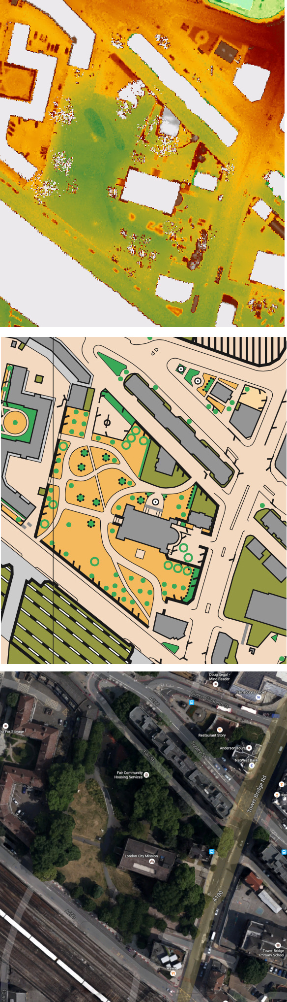
There are DSM and DTM DEMs (DSM including trees and other "natural" things etc) supplied in ASC format - it's a file of height measurements in millimetres, separated by 50cm, 1m or 2m depending on area. It's nice - big trees clearly visible, detailed building shapes etc.
Here's a comparison of the 50cm DSM with ISSOM(ish) for a map in south London (top 2014 and middle 2010 so there may have been some veg changes) + the 2015 Google aerial imagery:
Stop talking, start running.
-

Angry Haggis - blue
- Posts: 418
- Joined: Thu Feb 05, 2004 11:24 pm
- Location: London
Re: DTM height data
![]() by martin » Fri Oct 23, 2015 7:22 pm
by martin » Fri Oct 23, 2015 7:22 pm
Does anyone know how to download single km tiles of Lidar data from the environment agency now? They seem to be in 10 km by 10 km zip files with up to 100 tiles in each. OK for the low resolution or incomplete regions, but my computer gives up after downloading about 100Mytes of a full 500Mbyte zip file, so I get nothing!
- martin
- off string
- Posts: 47
- Joined: Wed Apr 16, 2008 1:16 pm
Re: DTM height data
![]() by Jagge » Fri Oct 23, 2015 8:49 pm
by Jagge » Fri Oct 23, 2015 8:49 pm
-
Jagge - white
- Posts: 61
- Joined: Mon May 08, 2006 1:40 pm
17 posts
• Page 1 of 2 • 1, 2
Who is online
Users browsing this forum: No registered users and 154 guests